
DGNSS receiver
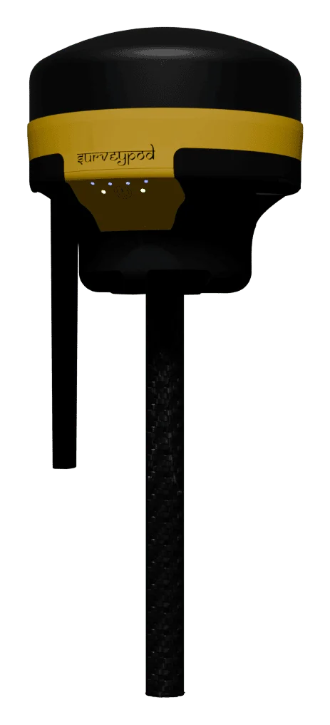
SurveyPod V1 DGNSS receiver
A rugged RTK and PPK receiver that works a full day on one charge.
- 7 mm
- horizontal accuracy, RTK
- 92
- satellites tracked, up to
- 16 h
- on a full charge
- 5 km
- LoRa radio range, up to
What it is
SurveyPod V1 is a differential GNSS receiver for control points, boundary surveys and stake-out. It tracks GPS, GLONASS, Galileo and BeiDou together, takes corrections by radio, internet or the CORS network, and runs for 16 hours in rover mode. It is also the natural partner for a survey drone: use it to measure ground control and check points.
What it does well
Four constellations
GPS, GLONASS, Galileo and BeiDou tracked together for a steady fix under trees and near buildings.
RTK, PPK or static
Real-time corrections when you need coordinates on the spot, post-processing when signal is unreliable, static for control.
CORS ready
Takes network corrections from CORS stations, so there is no base to set up where coverage exists.
Radio, Wi-Fi, Bluetooth
A 1 W LoRa radio for base-rover work, dual-band Wi-Fi for internet corrections, Bluetooth 5.0 to the controller app.
Standard data formats
RTCM3 and NTRIP corrections, CSV and DXF positions, RINEX raw data, plus NMEA output to GIS tools.
All-day battery
A 6,800 mAh battery lasts 16 hours as a rover and can be extended with external power.
Standard or tilt?
| SurveyPod V1 | SurveyPod V1 Tilt | |
|---|---|---|
| Pole must be vertical | Yes | No |
| Bubble levelling | Needed at every point | Not needed |
| Points near walls and fences | Difficult | Reached by leaning the pole |
| Speed per point | Standard | Faster |
| Tilt compensation | No | IMU, up to 60° |
Specifications
Accuracy
- RTK
- H 7 mm, V 14 mm
- PPK
- H 5 mm, V 8 mm
- Static
- H 4 mm, V 6 mm
Signals
- GPS / QZSS / SBAS
- L1C/A, L2C
- GLONASS
- L1OF, L2OF
- Galileo
- E1B/C, E5b
- BeiDou
- B1I, B2I
- Satellites tracked
- Up to 92
- Update rate
- Up to 10 Hz
Connectivity
- Radio
- LoRa, 1 W, up to 5 km
- Wi-Fi
- 2.4 GHz and 5 GHz
- Bluetooth
- 5.0
- Corrections
- RTCM3, NTRIP, CORS
Data
- Position formats
- CSV, DXF
- Raw data
- RINEX, logged at 1 Hz
- Storage
- 32 GB
- Output
- NMEA
Power and body
- Endurance
- 16 hours (rover mode)
- Battery
- Li-ion, 6,800 mAh, 7.4 V
- Charging
- 12–24 V, 2 A
- Size
- 140 × 140 × 160 mm
- Weight
- 1,150 g
- Protection
- Drizzle and dust proof
- Case
- Industrial hard case
Manufacturer’s published specifications, subject to change.
What is a DGNSS receiver used for?
Measuring positions on the ground to centimetre level or better: control points, boundaries, stake-out, and ground control and check points for drone surveys.
Should I use RTK or PPK?
Use RTK when you have a radio or internet link and want coordinates immediately. Use PPK where links are unreliable; corrections are applied after the survey.
Does SurveyPod work with the CORS network?
Yes. It accepts network RTK corrections from CORS stations over the internet, which removes the need for your own base station.
How long does the battery last?
About 16 hours in rover mode on a full charge, and it can run from external power for longer sessions.
Can I use it with my drone survey?
Yes. It is commonly used to measure ground control points that tie a drone map to real-world coordinates and verify its accuracy.
Have a project in the air?
Send us the site location and what you need to know about it. We will reply with scope, timeline and a quote.
- WhatsApp: +91 99091 00410
- Phone: +91 99091 00410
- Email: info@megatronixvision.com