
Survey and mapping drone
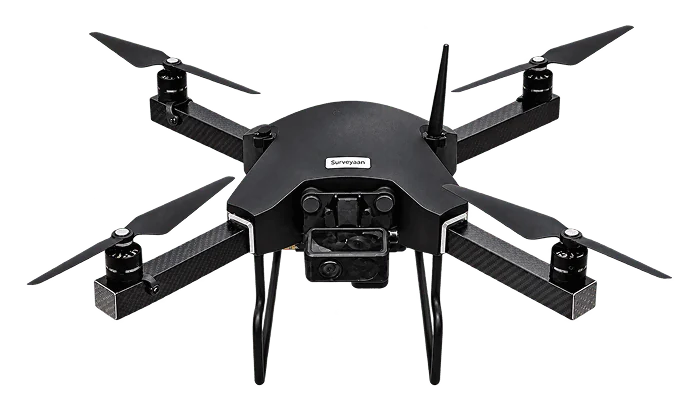
Surveyaan V1 survey drone
A type certified mapping drone that packs into a 50 cm bag and flies the survey itself.
- 25–30 min
- flight time
- 1.99 kg
- micro category
- 23 MP
- camera
- 60 ha
- mapped in about 25 minutes
What it is
The Surveyaan V1 is built for surveyors who want to map land without becoming pilots. You draw the area on the ground control app, the drone plans its own lines, flies them, and comes home. The photos go to cloud photogrammetry software and come back as an orthomosaic and terrain model.
Why surveyors choose it
DGCA type certified
A type certified aircraft in the micro category, which keeps compliance straightforward for commercial survey work in India.
Flies the mission itself
Mark the boundary on the app and the drone handles take-off, the survey lines and landing. Manual flying skill is not needed for mapping.
In the air in two minutes
Unfold, power on, connect. Setup and pre-flight checks are designed to take under two minutes.
Carbon fibre airframe
Carbon fibre composite and machined plastic keep the weight down and stand up to daily field use.
Picks up where it stopped
If the battery runs low the drone returns home by itself. Swap the battery and it resumes the mission from the point it left.
One-person kit
Drone, battery, charger and accessories weigh about 4 kg and pack into a 50 cm bag. A survey tripod is included.
Specifications
Aircraft
- Type
- Quad-rotor
- Category
- Micro
- Weight
- 1.99 kg
- Airframe
- Carbon fibre composite
- Certification
- DGCA type certified
Flight
- Flight time
- 25–30 minutes
- Range
- 1.5 km
- Maximum height
- 120 m
- Maximum speed
- 25 km/h
- Wind resistance
- Up to 25 km/h
Survey
- Camera
- 23 MP
- Coverage
- About 60 hectares in 25 minutes
- Accuracy with onboard GPS
- X/Y within 10 cm, Z within 15 cm
- Accuracy with ground control
- Follows the DGPS used for control
- Processing
- Cloud photogrammetry software
Kit
- Carry bag
- 50 cm × 50 cm
- Kit weight
- About 4 kg
- Ground station
- 200 g, Wi-Fi, 15 Wh
- Battery
- One included, extras available
- Tripod
- Included
Manufacturer’s published specifications, subject to change.
What is the Surveyaan V1 used for?
Land survey and mapping. It captures overlapping photos that are processed into 2D orthomosaic maps and 3D terrain models for topographic, boundary, construction and agriculture surveys.
How accurate is the Surveyaan V1?
With its onboard GPS the manufacturer states X/Y within 10 cm and Z within 15 cm. Using ground control points measured with a DGPS brings map accuracy in line with the DGPS used.
Do I need flying experience to operate it?
No manual flying is needed for survey missions. You mark the area in the app and the flight is autonomous. We provide training when you buy from us.
Can it fly in wind or rain?
It is rated for wind up to 25 km/h and should not be flown in rain. Failsafes bring the drone home and land it if conditions change mid-flight.
How many batteries come with the drone?
One battery is standard. We recommend at least one spare so larger areas can be completed with the resume function.
Have a project in the air?
Send us the site location and what you need to know about it. We will reply with scope, timeline and a quote.
- WhatsApp: +91 99091 00410
- Phone: +91 99091 00410
- Email: info@megatronixvision.com